Fahrradtour 2010-04-11: Difference between revisions
Jump to navigation
Jump to search
(Created page with 'Category:Recreation Category:Sports') |
No edit summary |
||
| Line 1: | Line 1: | ||
* Teilnehmer | |||
** Katja | |||
** Jochen | |||
** Jürgen | |||
** Ralf (oder Ralph?) | |||
** [[Heiko]] | |||
* Strecke | |||
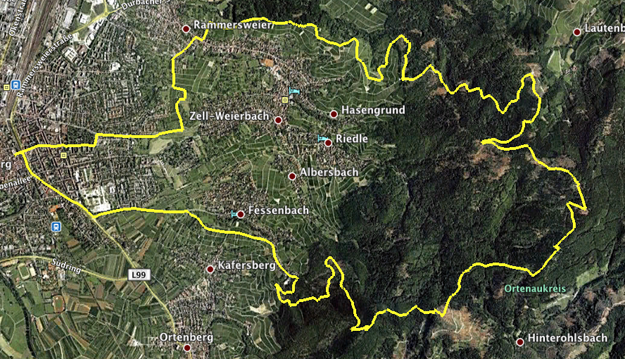
** [[Lindenplatz]] - [http://www.offenburg.de/html/zum_hohehornturm_ii.html Hohes Horn] - [http://de.wikipedia.org/wiki/Brandenkopf Brandenkopf] - [http://de.answers.yahoo.com/question/index?qid=20080217124955AA6bttH Absoloms Grab] - [http://maps.google.de/maps?client=safari&rls=en&q=wolfsgrube+offenburg Wolfsgrube] [http://www.offenburg.de/html/lindenhoehe.html Lindenhöhe] - [[Lindenplatz]]<br>[[Image:FahrradTour20100411Map.png]] | |||
** Höhenprofil<br>[[Image:ElevationProfile20100411.png]]<br>Höchster Punkt: 692m bei 10.53km. | |||
** Tracklog (gezippt): [[Media:Fahrradtour 2010-04-11GPX.zip]] | |||
** KMZ für Google Earth (gezippt): [[Media:Fahrradtour 2010-04-11.zip]] | |||
[[Category:Recreation]] | [[Category:Recreation]] | ||
[[Category:Sports]] | [[Category:Sports]] | ||
Revision as of 15:36, 11 April 2010
- Teilnehmer
- Katja
- Jochen
- Jürgen
- Ralf (oder Ralph?)
- Heiko
- Strecke
- Lindenplatz - Hohes Horn - Brandenkopf - Absoloms Grab - Wolfsgrube Lindenhöhe - Lindenplatz
- Höhenprofil
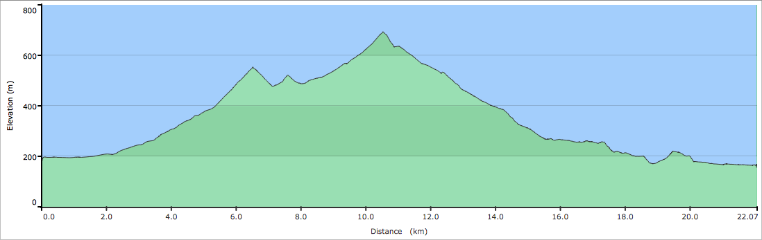
Höchster Punkt: 692m bei 10.53km. - Tracklog (gezippt): Media:Fahrradtour 2010-04-11GPX.zip
- KMZ für Google Earth (gezippt): Media:Fahrradtour 2010-04-11.zip
- Lindenplatz - Hohes Horn - Brandenkopf - Absoloms Grab - Wolfsgrube Lindenhöhe - Lindenplatz

