Hohes Horn-Fritscheneck-Kornebene-Fritscheneck-Winterwald 2010-05-23: Difference between revisions
Jump to navigation
Jump to search
(Created page with '=== Route === Offenburg - Hohes Horn - Fritscheneck - Kornebene - Fritscheneck - Winterwald === Elevation Profile === [[Offenburg - Hohes Horn - Fritscheneck - Kornebene - Frits…') |
No edit summary |
||
| Line 3: | Line 3: | ||
=== Elevation Profile === | === Elevation Profile === | ||
[[Offenburg - Hohes Horn - Fritscheneck - Kornebene - Fritscheneck - Winterwald Elevation 2010-05-23.png]] | [[Image:Offenburg - Hohes Horn - Fritscheneck - Kornebene - Fritscheneck - Winterwald Elevation 2010-05-23.png]] | ||
=== Facts === | === Facts === | ||
| Line 9: | Line 9: | ||
* 39km | * 39km | ||
* Downloads | * Downloads | ||
** [[Offenburg - Hohes Horn - Fritscheneck - Kornebene - Fritscheneck - Winterwald Elevation 2010-05-23.xls]] - Tracklog and Elevation data, done with [[GPSMinna]] | ** [[Image:Offenburg - Hohes Horn - Fritscheneck - Kornebene - Fritscheneck - Winterwald Elevation 2010-05-23.xls]] - Tracklog and Elevation data, done with [[GPSMinna]] | ||
** [[Offenburg - Hohes Horn - Fritscheneck - Kornebene - Fritscheneck - Winterwald Elevation 2010-05-23.kmz]] - KMZ for use with Google Earth | ** [[Image:Offenburg - Hohes Horn - Fritscheneck - Kornebene - Fritscheneck - Winterwald Elevation 2010-05-23.kmz]] - KMZ for use with Google Earth | ||
** [[Offenburg - Hohes Horn - Fritscheneck - Kornebene - Fritscheneck - Winterwald Elevation 2010-05-23.gpx]] - GPX | ** [[Image:Offenburg - Hohes Horn - Fritscheneck - Kornebene - Fritscheneck - Winterwald Elevation 2010-05-23.gpx]] - GPX | ||
[[Category:Recreation]] | [[Category:Recreation]] | ||
Revision as of 20:43, 23 May 2010
Route
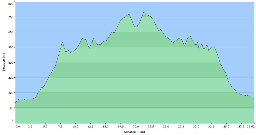
Offenburg - Hohes Horn - Fritscheneck - Kornebene - Fritscheneck - Winterwald
Elevation Profile
Facts
- 1151 m altitude difference
- 39km
- Downloads
- File:Offenburg - Hohes Horn - Fritscheneck - Kornebene - Fritscheneck - Winterwald Elevation 2010-05-23.xls - Tracklog and Elevation data, done with GPSMinna
- File:Offenburg - Hohes Horn - Fritscheneck - Kornebene - Fritscheneck - Winterwald Elevation 2010-05-23.kmz - KMZ for use with Google Earth
- File:Offenburg - Hohes Horn - Fritscheneck - Kornebene - Fritscheneck - Winterwald Elevation 2010-05-23.gpx - GPX
