Fahrradtour 2010-04-11: Difference between revisions
Jump to navigation
Jump to search
No edit summary |
No edit summary |
||
| (13 intermediate revisions by the same user not shown) | |||
| Line 1: | Line 1: | ||
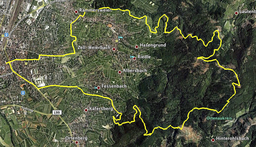
=== Strecke === | === Strecke === | ||
[[Lindenplatz]] - [http://www.offenburg.de/html/zum_hohehornturm_ii.html Hohes Horn] - [http:// | [[Lindenplatz]] - [http://www.offenburg.de/html/zum_hohehornturm_ii.html Hohes Horn] - Fritscheneck - [http://www.offenburg.de/html/brandeck-tour.html Brandeckturm] - [http://de.answers.yahoo.com/question/index?qid=20080217124955AA6bttH Absoloms Grab] - [http://maps.google.de/maps?client=safari&rls=en&q=wolfsgrube+offenburg Wolfsgrube] - [http://www.offenburg.de/html/lindenhoehe.html Lindenhöhe] - [[Lindenplatz]]<br> | ||
[[Image:FahrradTour20100411Map.png]] | |||
=== Höhenprofil === | === Höhenprofil === | ||
| Line 7: | Line 8: | ||
=== Langweilige Daten === | === Langweilige Daten === | ||
* | * [[Media:Fahrradtour 2010-04-11GPX.zip|Tracklog (gezippt)]] | ||
* | * [[Media:Fahrradtour 2010-04-11.zip|KMZ für Google Earth (gezippt)]] | ||
* Und dank [[GPSMinna]] das ganze noch in Excel, falls einer die geleisteten Höhenmeter ausrechnen will: | * Und dank [[GPSMinna]] das ganze noch in Excel, falls einer die geleisteten Höhenmeter<ref>Ich nehms mal vorweg, es sind 835m...</ref> ausrechnen will (gezippt<ref>Was sonst...</ref>): [[Media:Fahrradtour2010-04-11xlsx.zip|Fahrradtour2010-04-11xlsx.zip]] | ||
* You might also be interested in... | |||
** [[Kornebene und zurück 2010-04-25]] | |||
Fußnoten: | |||
<references/> | |||
[[Category: | [[Category:Mountainbiking]] | ||
[[Category:Sports]] | [[Category:Sports]] | ||
Latest revision as of 11:44, 9 June 2010
Strecke
Lindenplatz - Hohes Horn - Fritscheneck - Brandeckturm - Absoloms Grab - Wolfsgrube - Lindenhöhe - Lindenplatz

Höhenprofil

Höchster Punkt: 692m bei 10.53km.
Langweilige Daten
- Tracklog (gezippt)
- KMZ für Google Earth (gezippt)
- Und dank GPSMinna das ganze noch in Excel, falls einer die geleisteten Höhenmeter[1] ausrechnen will (gezippt[2]): Fahrradtour2010-04-11xlsx.zip
- You might also be interested in...
Fußnoten: